
Are you tasked with preparing a Landscape and Visual Impact Assessment (LVIA)? Are you uncertain about requirements or keen to sidestep drawn-out, ineffective negotiations? Impact assessment in project management is often challenging, requiring the communication of complex design proposals to stakeholders and community members with diverse views and preferences. Unlike other regulatory requirements, the criteria for judging and determining visual impacts can be notoriously subjective, leading to frustrating, costly, and prolonged mitigation processes. This is particularly the case when assessment methodology relies upon two-dimensional imagery that only partially represents anticipated changes or technical drawings and diagrams that are difficult for laypeople to interpret.
This article illustrates how realistic CGI simulations can transform Land and Visual Impact Assessment planning, with computer-generated ‘digital twins’ offering unprecedented clarity and understanding of design proposals. Powered by real-world data, these 3D models allow you to explore and experience visual impacts as if navigating through a future world. This allows viewers to fully comprehend a proposal, helping you to reach a consensus with affected parties much sooner and increasing the probability that a project will be well-received and positively impact the community for generations to come.
This article is written by Dr Ben Guy, who holds a PhD in Design-based Planning Systems and has two decades of experience helping companies prepare visual resources for impact analysis in project management within Australia, New Zealand, and beyond.
CONTENTS: Landscape Character Assessment | Visual Impact Assessment | Why is an LVIA important? | How to do an LVIA | What is assessed? | Visual character | Construction, operation, and maintenance impacts | Daylight analysis | Weather | Landscaping | Seasons | Impact on views | Virtual simulation of impacts | Our LVIA workflow | CGI Digital Twin benefits | Case studies | Winning community trust
Definitions: What is a Landscape and Visual Impact Assessment (LVIA)?
A Landscape and Visual Impact Assessment is the analysis of the visual impacts on the landscape or townscape resulting from a proposed or potential change in the spatial environment – typically from a development in property, energy, or transport infrastructure.
The primary objective is to aid decision-makers in predicting, understanding, and evaluating a development’s effects on the existing natural and built environment and its inhabitants. The aim is to determine whether a proposal will likely result in positive, neutral, or negative impacts – and to ensure that these are comprehensively understood and evaluated before the onset of construction.
Although the requirements for conducting an LVIA vary between countries and jurisdictions, this process typically involves two distinct components:
- Landscape Character Assessment (LCA)
- Visual Impact Assessment (VIA)
These assessments are separate yet interconnected, and the findings from one often inform the other.
What is a Landscape Character Assessment? (LCA)
A Landscape Character Assessment investigates the potential effects of a proposal on the unique characterof the landscape, identifying and predicting impacts upon physical landforms, urban and rural settings, waterways, vegetation, wildlife, and other aspects of the natural and built environment.
Landscape Character Assessment guidance emphasises the importance of respecting the distinguishing visual attributes that shape a landscape’s character, and may include analysis of geology, land use, as well as cultural and historical aspects. The goal of an LCA is to ensure that the intrinsic qualities of a landscape are preserved or enhanced, with new developments remaining sensitive to the existing environment.
As the most important tool for landscape analysis and decision-making assistance in Europe since the 21st century, LCA has been widely accepted as the foundation for city decision makers to achieve dynamic management, planning initiatives, and landscape protection.
– Yutian Lu, Sun Xu, Songxue Liu, and Jiayu Wu, An approach to urban landscape character assessment: Linking urban big data and machine learning (2022)[i]

What is a Visual Impact Assessment (VIA)
Visual impact in planning is defined as the impact upon what people see and involves assessing how a project development is likely to affect views and visual amenities (such as impacts upon the aesthetic or scenic value of a landscape or area). This assessment typically considers views from different locations, such as the view from nearby residences, workspaces, vehicles, and notable landmarks or public spaces.
A VIA is similar to the American Visual Resource Management framework used for identifying and conserving the aesthetic values of landscapes or environments.
Transport for New South Wales, Australia, makes the distinction between a landscape and visual assessment as follows:
Landscape character assessment helps determine the overall impact of a project on an area’s character and sense of place (what people think and feel about a place and how society values it, whether or not they are physically present at it). Visual impact assessment helps define the day to day visual effects of a project on people’s views (what people see at a place, when they are there).
– Centre for Urban Design, Transport for NSW, Guideline for landscape character and visual impact assessment, Environmental impact assessment practice note EIA-N04 (2022)[i]
Why are Landscape and Visual Impact Assessments important?
- Cultural reasons: Societies and communities treasure collective or singular visual fields and spatial experiences. We love Oxford Circus, Time Square, enchanting piazzas, and heritage views of Florence, Italy. If society is not careful, we have the potential to make all places homogenous, efficient, ugly, and depressing. Beautiful places are known to improve health and well-being – which is why people travel to such places during the weekend or holidays. This understanding is reflected in the design of modern smart hospitals like Adelaide’s NRAH, which incorporate views of trees and natural vistas to enhance healing properties.
- Economic reasons: Good views are worth a million dollars or more in the right place. For example, a harbour view can convert a dull apartment worth peanuts into a palace worth millions. What happens when that view is obscured? These scenarios open up questions about ‘view rights’ (in many jurisdictions, there are no legal guarantees that a property owner can preserve a view unless certain easements or specific local ordinances are in place).
- Environmental reasons: LVIA plays a critical role in protecting ecosystems and biodiversity, guiding developers towards minimising the footprint of their projects, promoting sustainability, and maintaining harmony with the landscape. In many countries, an LVIA forms part of an Environmental Impact Assessment (EIA) – a comprehensive process that documents mitigation measures to reduce air or water pollution, noise levels, disruption to local wildlife, and so on.
- Safety reasons: Visual issues can directly impact the safety of an operating environment. Humans use vision as a primary navigational tool. Dark and unsafe architectural environments with poor sightlines deter users. Excessive visual obstructions can introduce distracting light reflections or visual clutter on roads, railways, airfields and airports. Poorly positioned signs can wreak havoc. Interestingly, we are seeing automated navigation systems on cars use visual field perception more than LiDAR and scanning to interpret space, with high-contrast visual cues of key importance (e.g. line markings).

What can go wrong with Visual Impact Assessments?
Public concern over adverse visual impacts can be a major source of project opposition.
– Guidelines for the Visual Impact Assessment of Highway Projects, US Department of Transportation, Federal Highway Administration (2015)[iii]
Winning the ambiguous and unofficial ‘social license’ of approval can be as important as the environmental, safety, and functionality conditions in many projects. And sometimes it is even more important.
When it goes wrong, we see an increase in complaints and projects stalled. The bigger the community dissatisfaction, the more intense the reactions become – to the point of people marching in the streets.
The fear of community anxiety, resistance to change, and backlash has been noted in Council of Australian Governments (COAG) cities reports as an inhibitor to some projects. Even though a project may be critical for productivity and urban quality, with sufficient public resistance, a proposal can be just too hard to get off the ground.
Public servants want to avoid unhappy communities and stakeholders. As does the bureaucrat who receives complaints from ministers and mayors and is asked to respond promptly. Each response can take many days and may require explaining how the situation will play out from the objector’s viewpoint. This can be tedious and unsatisfactory work for all involved, and numerous things can go wrong, such as:
- Litigation: A typical urban planning scenario involves arguments over structures in the landscape or townscape and their visual impact. This can end in tribunals and legal proceedings between neighbours or communities over these impacts. Often this involves first getting to an agreement about the impact ‘quanta’ (or amount) then discussing or judging the effect of that impact.
- Rebuilding: When a project is operational, it may be discovered that infrastructure and other objects need to be moved, reconstructed or rebuilt. For example, signals or signage may be in the wrong location, or a blinding reflection from a new overpass may distract car or rail drivers. Rebuilding incurs considerable costs and loss of reputation.
- Time wasting: Sometimes there is excessive worry about visual impacts when these concerns are baseless, or an over-focus on a particular feature when the background of the environment makes this insignificant. It is essential to determine whether concern over a potential impact is warranted early in the planning process, so you can respond appropriately and stop wasting consulting money on the topic.
- Rejection: Stakeholders or the community may reject the proposed change, affecting your brand and reputation.
- Diminishing place value: Sometimes places are considered intrinsically valuable, and people may travel thousands of kilometres to experience these views and environments, both natural and built. Diminishing these values (or adding to them) can have a significant economic and cultural impact.
- Accidents and loss of life: As noted above, a visual environment can adversely impact operations – such as blinding reflections on a highway from a glazed building at sunset. Getting an LVIA right helps to avoid these negative downstream consequences.

How to do an LVIA
Although guidelines for Landscape and Visual Impact Assessment vary between countries and jurisdictions, the process of preparing an LVIA often begins with a baseline impact assessment, establishing the scope and methodology of the submission. This is sometimes followed by a landscape character assessment and sensitivity study, which helps to illuminate the site’s unique attributes and vulnerabilities. This process also involves identifying key viewpoints and viewers of the project (residents and users of local amenities, for example).
Initial stages may involve desk-based research into the site’s topography, land use, ecological features, and historical and cultural context. Early investigations are often complemented with a field survey, with photos and video footage taken from key viewpoints. During this phase, various impact assessment techniques can be employed to collect relevant data, such as an impact assessment questionnaire, to establish whether the project will likely elicit controversy or opposition. Given the subjective nature of aesthetic issues, public consultation is an important component of an LVIA.
After collating this information, anticipated visual impacts can be evaluated. These are assessed in terms of their proximity and magnitude, determining whether these are likely to be beneficial, neutral, or adverse. The final step is to develop and articulate measures to mitigate any adverse effects, which might involve adjusting the project design, scale, or materials.
The resulting Landscape Visual Assessment report is a comprehensive, descriptive, and illustrative document, capturing the qualities and value of the existing environment and the anticipated changes – often accompanied by a visual impact statement detailing the particular challenges that emerge in relation to the needs of the project.
What should Visual Impact Assessment include?
When preparing an LVIA as part of a planning application, compelling visual evidence is essential. This is because in order to understand visual impacts, these must first be seen.
For the past few decades, LVIA has been supported by CAD plans, GIS, visual impact photography, design renders, zoning maps, topographical maps, landscape character assessment maps, satellite imagery, impact score diagrams (graphs, templates, or tables summarising or quantifying impacts), shadow diagrams, height diagrams, line-of-site diagrams, viewshed analysis, and photomontages to approximate visual impacts.
This approach has many limitations that challenge effective community engagement. Navigating and cross-referencing between multiple documents and illustrations, deciphering technical diagrams, and understanding complex jargon can render the LVIA inaccessible for many.
The primary drawback of relying on 2D images within the LVIA is that these illustrate a proposal from only one viewpoint. Even if documents are clear and easily interpreted, relying on isolated key views is fraught with risk. Chosen renders may omit important details or fail to depict a design in its entirety. Foreground elements may screen certain design aspects, important contextual information may be left out, or selective viewpoints may introduce distortion or a misleading sense of proportion due to the way the image is framed or cropped.[iv]
As Brian Reed points out in ‘An Introduction to Visual Impact Assessment’ (2017)[v], photographs do not always capture a landscape’s dynamic nature, which might include running water, swaying plants, or bustling streets. 2D images are often devoid of the sense of life and movement that profoundly impact our perception of space.
In the past, scale models have been one method for communicating a more comprehensive view of a project; however, these do not allow you to view the project from the human scale, nor to understand what it might be like to walk through the project, or see it integrated within the existing environment. For this reason, project managers are turning to digital simulation.
Physical models are now being superseded by computer models that allow the viewer to ‘move’ through a three dimensional landscape, looking at the development from different angles. Other computer methods include geographical information systems (GIS), where databases can be used to identify particular zones comparing, for example, vegetation or land use with altitude or orientation.
– Brian Reed, An introduction to visual impact assessment, Water, Engineering and Development Centre (WEDC), School of Civil and Building Engineering, Loughborough University (2017)[v]
In the 21st Century, the new tools we have available include photorealistic, geo-spatially accurate and interactive real-time CGI environments with precision cameras, and shadow and lighting analysis. CGI is a game changer for the LVIA, reducing the cost and time involved, and improving precision and certainty by orders of magnitude. The digital production of 3D models is particularly essential in projects that are complex, controversial, or of high public concern. If you are still using static plans, elevations, cross-sections and photo-montages – please get in touch or continue reading to understand the new methods and workflows available with Urban CGI technology.

What kind of visual impacts can CGI assess and analyse?
CGI simulations can simplify many forms of project impact analysis. Here are just some of the visual impacts that can be communicated via a 3D real-time virtual model:
Visual character
The visual impact of a design – whether it be an urban environment, an architectural project, or an infrastructure development – can be evaluated in much the same way as a piece of art, taking into account the relationships between visual elements such as line, tone, colour, shape, form, texture, and space. These interact in different ways, giving rise to visual principles such as balance, contrast, emphasis, scale, proportion, pattern, rhythm, unity, and so on.
Aesthetic elements cannot be evaluated in isolation. Our perception of colour, for instance, is strongly influenced by adjacent colours (optical illusions often manipulate this to great advantage). Similarly, lines within structural elements direct our vision. Contrasting patterns, surfaces, and details can have numerous unexpected consequences that should be envisioned and considered.
A realistic 3D model makes this evaluation much easier and immediately communicates a sense of scale and proportion. The effect of materials and surface qualities are also clearly visible, as well as how open/spacious or enclosed/contained an area feels.
Space is an important factor in urban design. Being exposed in an overly large expanse, unprotected and vulnerable, is rarely attractive. People prefer spaces with shelter and protection at their back. We naturally sit around the edges of squares and piazzas, with our back to the facades, looking out over the activity in the centre. This way we can see friend, foe (or food) approaching.
Industrial and architectural landscapes are particularly concerned with the arrangement of geometries and form in space, as well as textural and light effects, creating ‘gestalts’ and a sense of character that gives rise to emergent properties, where the whole exceeds the sum of its parts. These emergent properties may be treasured and independent of style.
Although there are many opinions about what constitutes good style, we know good urban space when we see it.
Humans have been making decisions about space and urban design since the dawn of time. Good judgement of space suitability was required in order to survive. Our ancestors who chose spaces wisely would have had a competitive advantage. Those who didn’t may have perished. This spatial ability is now ingrained within your limbic system, along with ‘fight or flight’ responses.
Sight is the most utilised sense for this ability. You innately assess space – its edges, proportion, features and content – continuously and subconsciously.
It is this judgement of space and form by sight that informs our innate ability to understand and engage in meaningful dialogue about space.
This is the reason why we all can make powerful, instantaneous judgements of incredibly complex spaces using CGI simulations. It is the 3D visual perspective in a real-time free-ranging format that most mimics this inherent ability.
If you want to make it easy to understand, develop, conceptualise and review complex urban spaces or infrastructure projects, 3D real-time computer graphic representations of environments is the ultimate format. It allows you to understand the scenario and see how all these pieces fit together. Anyone can understand your proposal – instantly. No need to learn or interpret.
With the right toolset, your audience and team ‘get it’ as fast as it takes to respond to an imminent threat. It is primal and intuitive, ingrained within your limbic system.

Construction methods, operating environment, and maintenance impacts
When preparing an LVIA, it is important to consider not just the visual impacts of a project once completed, but also during construction and maintenance periods. Construction methods can cause visual disruptions due to the presence of equipment, personnel, earthworks, or the removal of vegetation. Noise, dust, and light pollution during construction can impact the visual and sensory qualities of the surroundings. Regular maintenance may involve the periodic presence of vehicles and staff, necessitating scaffolding, temporary structures, or even partial closures.
The operating environment of the project can also significantly alter the visual and experiential qualities of the landscape. This can lead to long-term visual impacts that must be evaluated and addressed in the LVIA. For example, there may be issues related to noise, lighting, emissions, glare, signage, signals, and changes in traffic patterns. These impacts should be considered in terms of proximity and duration, with strategies developed to reduce severity and frequency where possible.
Lighting conditions and daylight analysis
Evaluating lighting changes is an important aspect of the LVIA. Quantity and quality of light can dramatically influence our experience of architecture and built environments, affecting visual acuity, perception of form, and the overall visual character of a place.
Daylight assessment using traditional methods is difficult, often relying on rough estimates or physical models. CGI technology now offers interactive ways to accurately visualise the trajectory of the sun and its effect on an environment at different times of the day.
Our CGI Digital Twins take into account the specifics of a site, including topography, vegetation, and built environment. They can even account for the reflective or light-absorbing properties of materials, mimicking the way light behaves in the real world. Our technology includes daylight analysis software, modelling absorption, reflection, and refraction, letting you accurately envision what a project will look like at dusk, in the morning, during peak sunlight hours, or even during the middle of the night when lit by street lamps.
Daylight assessment planning of this type allows you to establish whether a proposal will result in overshadowing, light spillage onto nearby properties or roadways, or has unsafe zones that are poorly lit. Simulations also help minimise light pollution, which is undesirable for insects, birds, and other flying creatures who navigate using light.

Atmospheric and weather changes
An LVIA should also consider predicted or episodic atmospheric and weather changes, as these can significantly influence visibility and lighting conditions (such as the darkening of the sky during rain or the luminosity of snow), affecting the perception of colour, texture, and distance.
CGI software has advanced capabilities for simulating a wide range of atmospheric and weather conditions, including changes in cloud cover, precipitation, and other atmospheric effects, and can accurately represent the scattering and absorption of light in fluctuating conditions, such as during rainfall, fog, snow, and wind. All of these things influence the overall visual character of a location.

Vegetation, agricultural, and landscaping impacts
Does the alteration borrow from the natural character of the landscape? Does the shape of the alteration reflect the shapes found in the natural landscape (e.g., rounded curvilinear shapes on rounded landforms; spiky more jagged shapes in rugged terrain), and does the cutblock respond to natural vegetation patterns and openings in both scale and shape? For example, if the landscape is forested with small discrete rock outcrops, does the harvest proposal mimic this pattern?
– Visual Impact Assessment Handbook, Forest and Range Practices Act, British Columbia, Canada (2022)[vi]
Infrastructure and urban design projects affect vegetation and landscaping in several ways, sometimes resulting in a loss of plant biodiversity, disruptions to nearby agricultural operations, and interference with local ecosystems and drainage patterns. These impacts can have significant visual and environmental implications, altering the perceived character of a landscape.
Design proposals often include alterations or additions to existing plants, shrubs, grasses, shrubs, and trees for aesthetic and functional reasons – such as stabilising a land mass and reducing erosion risk or providing a visual barrier. All of these aspects need to be considered and envisioned in detail. For example, boundaries of cleared vegetation may need to be staggered and uneven, so as to appear like a natural clearing, rather than a manmade gash in the landscape.[ii]
Digital environmental impact assessment using CGI technology allows you to model landscape morphology precisely, with terrain mapped directly from aerial LiDAR (Light Detection and Ranging) scans, ensuring every contour and feature of the landscape is accurately represented. Different plant species can be represented with a high degree of fidelity, with the detail dependent upon the 3D models and textures used. This lets you envision different heights, densities, and species of vegetation and see how these changes affect the sense of space.

Seasonal and life cycle changes
Seasonal changes can significantly alter the appearance of a project. For instance, trees may be fully leafed in the summer, providing screening, but bare in the winter, exposing less-attractive facades to disgruntled neighbours. Similarly, wildlife patterns, lighting conditions, and human activity often vary substantially according to seasonal patterns.
Advanced CGI technology can model the impact of these changes and allows you to switch off different layers within the simulation, hiding vegetation at the click of a button. This is particularly useful when you want to study the structure in isolation, ensuring the design is well-balanced and cohesive in its own right. Control over the visualisation of isolated components in a project is part of what makes CGI simulations so valuable for visual impact assessments.

Impact on views
Assessing changes to views is a fundamental part of the LVIA. A common first step is to conduct a viewshed analysis establishing the ‘Zone of Theoretical Visibility,’ mapping from where a new proposal will be seen. This type of geographic analysis determines the visibility of a single point from other locations in the landscape. A viewshed map is often used in planning and environmental studies to understand which regions within a landscape will be able to see a particular feature or new development.

Obstructions, screenings, and limits to view
Buildings, walls, trees, signage, and numerous other infrastructure elements can block lines of sight, hindering vision from a particular viewpoint. Sometimes this is deliberate, with features concealing less attractive aspects of a project, minimising unwanted visual impacts. Vegetation, earth mounds, and structures can be strategically positioned, for example, so that jarring elements of a proposal do not intrude upon or detract from the existing environment.

Height evaluations
The height of a new structure can dramatically impact our perception of a landscape, altering views, disrupting the skyline, or overshadowing nearby areas and restricting light availability. Height changes can be particularly noticeable if a structure is significantly taller or shorter than the surrounding buildings, leading to a sense of incongruity, whereby the development feels out of place. Height maps are especially helpful, allowing stakeholders to visualise a proposal in context, assessing its compatibility with the surrounding environment.

Serial vision and dynamic viewpoints
View lines are not just static. Serial vision is the experience of ‘moving through the environment.’ CGI technology lets you dynamically assess the surroundings from a shifting vantage point, making it possible to simulate the journey of a pedestrian, cyclist, motorist, rail driver, or machinery operator in real-time – at eye level as you move through virtual space. This makes it far easier to appreciate the effect of distance and perspective and to experience the unfolding sequence of views as you travel across the landscape. (Read more about serial vision in urban design here.)

Vistas and heritage views
Vast, scenic, or picturesque views can be enhanced, obscured, expanded, or even created by new development projects – such as when an elevated building reveals previously inaccessible viewpoints or when a new structure itself becomes a notable landmark. Visual impact assessment involves consideration of the views of heritage items and landmarks, and the framing and accessibility of pleasing views of the surrounding environment.
Digital twins allow for clear assessment of these impacts, simulating a proposal from every angle and perspective. CGI technology can even mimic the effects of atmospheric perspective – such as how distant objects appear paler, hazier and less distinct – helping you plan the integration of captivating views.
Cumulative impacts
Modifying a small design feature, like signage, might not seem a significant change. However, the combined effect of many small changes can have substantial unintended consequences.
One of the great strengths of CGI is that it represents the combined interplay of all of these separate elements, seamlessly collating multiple data streams into a single 3D model. This allows for feature impact assessment to occur as part of the whole, in context, just as the project will be assessed in real life.
What types of Visual Impact Assessments can CGI improve?
Here are some of the key areas in which our clients find our CGI simulation software of great use:
- Architectural form and urban design and visual impact assessment – including sympathy to heritage townscapes, variation of skylines, and other interactions between place and community.
- Property view yields – including residential visual amenity assessment and assessing views from new apartments. Capturing these view yields early in the process can improve revenue at little cost. It is always best to do this form of analysis before designs get locked in.
- Environmental and landscape impact assessment – including land use issues, as well as changed morphologies and geometries with a landscape’s physiology due to quarries, mines, excavation, retaining walls, cuts and fills, slope gradients, vegetation removal, energy generation equipment, and their impact on environment.
- Visual assessment of structures above and around water – including road bridges, railway bridges, and ports. These may have special aesthetic considerations related to reflections, shoreline development (the interface between land and water), clarity and discolouration of water due to pollution, movement and fluctuations due to tides, flooding, rising water levels, floating infrastructure, and so on.
- Transport safety auditing – including railway, road, and airports. We have considerable expertise in rail signal sighting, rail alignment planning, and visual impact assessment for highway projects. We also have extensive experience with road safety auditing to national standards. Spatial configurations largely determine the field of vision available to commuters, with horizontal curvature, linearity, and the steepness of incline and contour significantly affecting the visual character and safety of these operations.
- Monuments, artifacts, art, and landmarks – including historic places, archaeological sites, shrines, and iconic cultural resources.
- Political event safety and sniper scenario simulations – including events, marches, and public gatherings. We have experience working for the military and modelling political events. We provide comprehensive event analysis and testing, and have experience with precision sniper-accurate view analysis, ensuring safe vantage points, including physics acceleration.
- Ticketing and Events visual sighting – including optimising of seating layouts. We can test visibility from different seating positions, helping you enhance ticket sales (best views of the event), allowing you to be sure of your arrangements, maximising view lines and prices. We can also simulate environmental impacts if you are in an outdoor environment.
- Signage, billboard, and advertising impact – both to maximise sightlines and to ensure that graphics are positioned safely, without compromising heritage or landscape values, while avoiding ‘visual pollution’ (visual pollution is the negative impact upon a visual scene caused by intrusive or out-of-character elements – an issue which often comes up in relation to unsightly advertising or billboards). Analysis of this type may include consideration of sign supports and lighting, as well as impacts upon traffic and pedestrian flow.

How do we provide Landscape and Visual Impact Assessments?
Although our precise workflow varies depending upon your project requirements, the LVIA process typically involves the following:
- The environment build: We aggregate a spatially accurate environment in our 3D interactive digital twins technology, establishing the existing conditions.
- The asset build: We model the object or asset in 3D to the level of detailing required, with options or not, as needed.
- The change: We insert or add the proposed design changes geographically and spatially within the digital environment, removing the existing assets in that place, where appropriate, and integrating all additions accurately and seamlessly.
- The edit: We adjust materials, features and details to meet your specifications, helping you refine the concept design to avoid and minimise adverse visual impact.
- The measurements: We measure spatially with various types of tools.
- The experience: We provide the ‘new’ experience of the proposed scenario in an interactive visual format.
- The outputs: We provide reports, animations, 3D renders, 3D maps, sections, elevations, perspectives, and so on.
Why are Urban CGI’s visual impact assessments better?
Here are some of the key benefits of using our CGI Digital Twins for the LVIA:
- The scale: We can manage thousands of square kilometres within a single model, easily navigating changes in scale.
- Accuracy of data: We offer a per vertex accuracy guarantee, using spatially accurate survey data from any source, including ground and aerial LiDAR and high-resolution photomeshes. We offer total certainty, with technical, measurable, verifiable, and auditable models.
- Infinite viewpoints: Urban CGI technology allows you to access every view under every condition: sunset, sunrise, every season – capturing every footstep from every part of huge cities.
- Rapid delivery: Our production pipeline is efficient, and we deliver on time. You can even shorten the anticipated approval timelines.
- Acceleration of the consultation process, saving time and money: Every complaint to the minister, letter to the editor, house-to-house visit, or public meeting (especially the more tense ones) has considerable financial cost. With our rapid real-time CGI technology you can communicate your proposal live – right then and there – in meetings, within the courtroom, with the barrister, or in virtual meetings, helping stakeholders and affected parties reach consensus faster and increasing staff satisfaction. Reducing these engagements from five to one has significant savings in time and reduces the overall Landscape Visual Assessment cost.
- Confidence and heightened control: With an easy-to-use simulation platform, communications managers find they can respond to contractors or suppliers about impacts and context matters with credibility. For example, a pedestrian overpass hovering amidst houses was having an unnecessarily adverse effect on privacy. Negotiating with an evidence-based visual tool unequivocally demonstrated the issues. Rapid understanding, with some minor low-cost changes, gave a great, fast, and easy resolution.
- No need for ‘trust me, I am an expert’: Running on spatial data, our digital twins make the proofs explicit so that anyone can understand what is proposed. Rather than having to rely on Landscape and Visual Impact Assessment consultants and assessment specialists to interpret and communicate complex documents, our 3D digital models are immediately accessible, without technical skills required. At one event, 300 anxious locals lined up behind the visual platform at a community meeting. Each person or family wanted to see exactly how the proposal would affect their personal user experience and impact their lives. The attendees that leave our transparent design review meetings feel informed and empowered. Tensions are often resolved and many thank the staff for their professionalism. Our digital presentations can be a major turnaround for a project, making for greater efficiency and satisfaction in consultation. The healing effect across communities can be transformational.
- Live capture videos: We can add technical videos of the proposal in context with live-stream video capture. Visual impact video production services can also be used to create professional animations as well as marketing and communications collateral.
- 10,000 images: Many of our clients require thousands of images representing multiple options from individual viewer perspectives to create assurance and speed up project proceedings. You no longer have to rely on a few isolated viewpoints that might fail to account for a particular visual impact. With our CGI Digital Twin model, images can be captured with ease, covering every viewpoint possible.
- Photomontages: We can easily add these for further verification, but with the power of our 3D models, you no longer have to rely on them on their own.
- Real-time optioneering: Explore live options of geometries and shapes in context to find the perfect silhouette and form for sensitive locations. Responsive analysis testing can save you months of time, and money on consulting fees, helping you avoid litigation and stakeholder issues. Live optioneering lets you quickly evaluate how design alterations will impact the surroundings. If utilised in the conceptual stages of a project, this exploration lets you generate solutions that can avoid or minimise undesirable impacts down the line. We have seen over and over again how early implementation of our 3D simulations greatly improves visual impact outcomes.
- Clear mitigation strategies that integrate seamlessly with the design: When modifying a design within a 3D virtual space, you can see instantly whether something ‘works.’ Adjustments on the fly can continue until every team member is satisfied that a successful resolution has been reached. Working iteratively in this manner ensures that remedies to adverse impacts are not awkward, last-minute ‘add-ons’ but are an integral element of the design.
A visual impact assessment (VIA) is not just a visual simulation – it is an iterative process that involves selecting viewpoints, taking photographs, developing design options, simulating proposed cutblocks and roads, and evaluating the simulations…
– Visual Impact Assessment Handbook, Forest and Range Practices Act, British Columbia, Canada (2022)[vi]
Urban CGI Landscape and Visual Impact examples
Here are just a few of the many LVIA projects we have worked on over the last twenty years:
Visual impacts communicated to the community via interactive portal – NELP

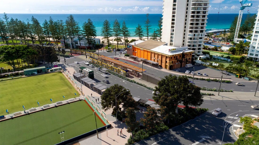
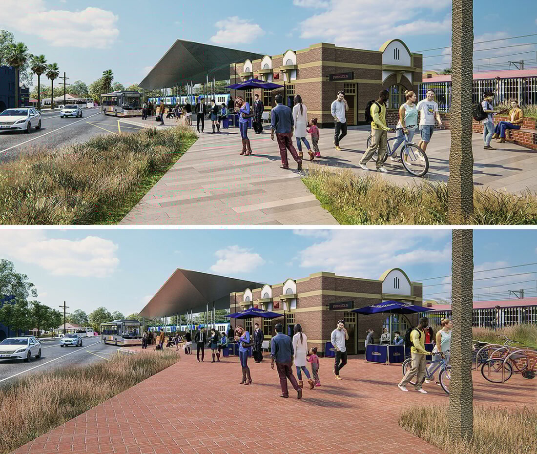
Rail station impacts and privacy analysis – Urban Infra LX CD9
This project involved the review of a rail station integration into the existing city infrastructure. Our digital twin model defines alignments, predicts safety factors, enables parameter fencing planning, and simulates lighting conditions and shadows cast over existing buildings. In this way, the model facilitates visual impact analyses, improving the quality of our urban spaces, accelerating decisions and fast-tracking approvals processes.
Particular sensitive VIA issues in this case study included:
- Rail screen heights and views of passengers into private homes and yards – optioneering and the development of appropriate screen heights, translucency and patterns tested in the digital twin environment.
- Views from private spaces to the new infrastructure.
- Safety and sightlines for users of the adjacent and newly developed public spaces under the rail infrastructure – play spaces in particular.
- Rail driver safety – verifying sightlines to platforms, new gantry designs, around the environment, to and from operational spaces.
Protection of established trees – landscape impact analysis, Pakenham

Shrine of Remembrance – impact upon precinct views

Tower crane installation – visual amenity impacts

See how we can help you to win trust with the community
The public wants to know what is going on in their environment, and they expect best practice. This is not just a NIMBY (“not in my backyard”) phenomena – it is a growing social conscience of what is good planning and design, and a desire for the best outcomes for the city, state, or locality.
But how do you gain this social license and support from a community? Often, we see the engineer personality at community events with impenetrable plans and an inability to socially engage, the architect defending the glory of their monument from selected viewpoints, and an army of wordsmiths with a pile of reports and brochures.
There is often a complete lack of trust, and sometimes of respect, between communities and experts. We all know how often information is presented in the ‘best light’ – and the 50 revisions of the brochure full of misleading words.
The best approach is complete and open transparency. To allow people to see how a new project will directly influence their life and environment – and to do so in the simplest way. Why should it be hard? Why should the public need to sift through hundreds of pages or assimilate abstract drawings in their head?
People want to know: How will this new road look from my back door? How will it affect the sidewalk, or the park where I walk my dog? What if it rains? How does it integrate with other facilities? Will it add or remove value for the local area? Will my neighbourhood be better for the change?
In order to win this social license, you need the community and the stakeholders to be convinced that they are completely aware of the anticipated change – from every experience and perspective of interest.
When full visibility is provided, even when the most drastic changes are being proposed, people are much more likely to buy into the project. Take away the razzle-dazzle of over-manipulated information, and instead make it open and immersive. Remove the need to convert and interpret abstract plans and drawings.
Across thousands of experiences with community members and other stakeholders, including industry professionals, we see the light bulb go on, anxiety and worry vanish and the immediate realisation of understanding.
Not being able to understand something makes people anxious. So the sooner you can facilitate true understanding, the sooner you can win the social license.
When projects and plans are transparently revealed in a virtual replication, anxieties are eliminated, people become calm, and objectors can even become evangelists. Residents aren’t intentionally hindering your work – they just need to understand and feel reassured that they are not going to lose something valuable. And the easiest way to do this is to see how all the pieces fit together, clearly, accurately, and simply.
We have over 20 years of experience doing highly complex LVIA and VIAs, and have saved (and made) clients millions of dollars regularly. During this time, we have refined our visual assessment methodology through involvement in hundreds of complex urban development projects. We have a human-centred approach and are perfectly placed to simplify this complexity and map a clear pathway forward for your project.
I’ve now used a number of packages for 3D modelling, including those in use by other Councils and Government departments. I have found UC’s software by far the easiest to navigate and manipulate. The features and tools are all intuitive; the advanced analysis functionality that it can provide, such as instant shadow and view line calculations have saved a great deal of time.
The software has proved invaluable at many high-level meetings with developers and architects. Being able to view a building proposal within its context, and to test heights, setbacks, floor areas and shadows with a few clicks of the mouse mean huge savings in time and resources, as well as being able to provide instant answers to questions.
– David Sowiński, Senior Urban Designer, Victoria
If you would like to discuss how we can help you with your landscape or visual impact analysis, please get in touch. We are based in Melbourne, Australia, and work with clients all over the world. We would love to hear from you!
REFERENCES
[i] Yutian Lu, Sun Xu, Songxue Liu, and Jiayu Wu, An approach to urban landscape character assessment: Linking urban big data and machine learning (2022)
[ii] Centre for Urban Design, Transport for NSW, Guideline for landscape character and visual impact assessment, Environmental impact assessment practice note EIA-N04 (2022)
[iii] Guidelines for the Visual Impact Assessment of Highway Projects, US Department of Transportation, Federal Highway Administration (2015)
[iv] Lisa Rimmer, Visual Assessment Best Practice Methodologies, LASC 698 Research Placement Report (2007)
[v] Brian Reed, An introduction to visual impact assessment, Water, Engineering and Development Centre (WEDC), School of Civil and Building Engineering, Loughborough University (2017)
[vi] Visual Impact Assessment Handbook, Visual Impact Forest and Range Practices Act, British Columbia, Canada (2022)


